Browse Digital Heritage
Search
Sort
Community
- (-) Remove Hoonah Community Members filter Hoonah Community Members
Collection
- (-) Remove Library of Congress filter Library of Congress
Category
- (-) Remove People and Places filter People and Places
Digital Heritage
Community
Hoonah Community MembersCategory
People and PlacesSummary
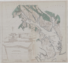
This map shows the location of current glaciers and where they were located at the time of being recorded by Capt. Vancouver in 1796.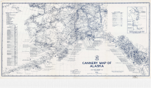
Digital Heritage
Community
Hoonah Community MembersCategory
People and PlacesSummary
This map shows the locations and names of the salmon canneries that were operating in Alaska in 1949.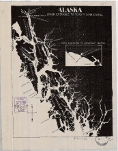
Digital Heritage
Community
Hoonah Community MembersCategory
People and PlacesSummary
This map shows the names and locations of the major fish companies operating in Southeast Alaska in 1903.
Digital Heritage
Community
Hoonah Community MembersCategory
People and PlacesSummary
Alaska and Canada boundary is decided through binding arbitration from an international tribunal in 1903.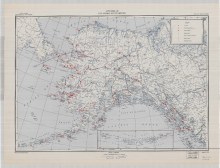
Digital Heritage
Community
Hoonah Community MembersCategory
People and PlacesSummary
This map shows the territory wide distribution of hospitals, Native schools, Native stores, medical services and radio stations present in 1947.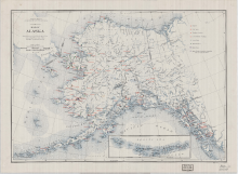
Digital Heritage
Community
Hoonah Community MembersCategory
People and PlacesSummary
This map shows the territory wide distribution of hospitals, Native schools, Native stores, medical services and radio stations in 1937.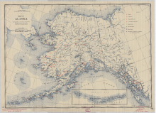
Digital Heritage
Community
Hoonah Community MembersCategory
People and PlacesSummary
This map shows the territory wide distribution of hospitals, Native schools, Native stores, medical services, and radio stations present in 1940. 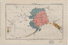
Digital Heritage
Community
Hoonah Community MembersCategory
People and PlacesSummary
The map shows the distribution of the different indigenous people of Alaska based on linguistic stock that was reported in 1920.