Skip to main content
Log in
Toggle navigation
Menu
About
Browse
Categories
Collections
Home
Map
Map
Last changed on Wed, 12/31/1969 - 16:00
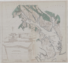
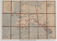
Alaska Glacier Bay 1925 Map
Digital Heritage
Community
Hoonah Community Members
Category
People and Places
Summary
This map shows the location of current glaciers and where they were located at the time of being recorded by Capt. Vancouver in 1796.
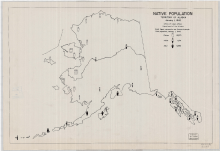
Alaska Ethnography Total Population of Eskimo Indian and Aleut 1942 Map
Digital Heritage
Community
Hoonah Community Members
Category
People and Places
Summary
This map shows the number of Eskimo, Aleut and Indian people and their distribution within the state in 1942.
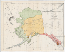
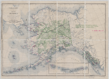
Map of Alaska Ethnography Distribution of Native Tribes 1880
Digital Heritage
Community
Hoonah Community Members
Category
People and Places
Summary
This map shows the geographical locations of the major tribes that existed in 1880 in the Territory of Alaska.
Alaska Education Native Schools Map 1919
Digital Heritage
Community
Hoonah Community Members
Category
People and Places
Summary
This map shows the distribution of Native schools throughout the Territory of Alaska at this time period.
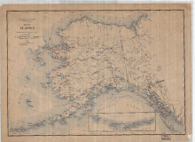
Alaska School Districts 1909 US Geological Survey
Digital Heritage
Community
Hoonah Community Members
Category
People and Places
Summary
District boundaries, proposed schools, and current existing schools.
1927 Alaska Education Native Schools
Digital Heritage
Community
Hoonah Community Members
Category
People and Places
Summary
Locations of Natives Schools throughout Alaska 1927, US Geological Survey.
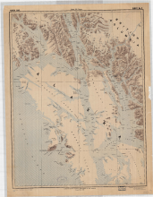
Chichagof Baranof Map 1941
Digital Heritage
Community
Hoonah Community Members
Category
People and Places
Summary
Map shows Admiralty, Baranof and Chichagof islands with named locations
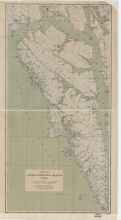
Alexander Archipelago 1898 Map
Digital Heritage
Community
Hoonah Community Members
Category
People and Places
Summary
The area covered in this map shows most of the territory of the Tlingit people.
first
previous
1
2